Is a Super El Niño on the Horizon? Here’s What That Could Mean
Author
Published
5/28/2026
El Niño is a phenomenon in which the trade winds, that typically move east to west along the equator, weaken. This allows warm water to drift back to the Americas (Figure 1). The latest predictions by NOAA’s Climate Prediction Center indicate an 82% chance of El Niño emerging in May to July 2026 (Figure 2). Probabilities for a very strong El Niño increase beginning in August to September and persist until December to February. Probability of a very strong El Niño are greatest (37%) from November to January. While every El Niño can behave differently, the impacts can be widespread and last for months rather than being a single weather event.
Strength is often dependent on sea-surface temperatures in the tropical Pacific Ocean. A weak El Niño occurs when temperatures are 0.5° C above average for an extended period of time, a very strong El Niño occurs when temperatures are at least 2° C above average for several months.
While rare, a very strong or “Super El Niño” has increasing chances beginning the last few months of the year. The last very strong El Niño was in 2015-16, however, the most recent El Niño occurred in 2023-24 but was categorized as strong. Since then, the past three El Niño’s have been weak contributing to milder seasonal shifts relative to temperature and precipitation impacts of a stronger event. El Niño can lead to significant rainfall in some areas, while others experience prolonged periods of significant heat and dry conditions. A Super El Niño does not necessarily suggest that the weather impacts will be stronger but rather increases the likelihood that certain weather impacts could happen.
In Iowa, depending on the season, El Niño can have very apparent impacts on weather further impacting crop conditions and soil moisture when applicable. With chances of a Super El Niño beginning late this summer, rainfall in Iowa and throughout the Midwest would likely impact this year’s crop. Summer weather patterns during El Niño are often marked by cooler temperatures and increased precipitation. Challenges with excessive rainfall can lead to flooded fields, pollination impacts, and pod/kernel count. Timing of rainfall is just as important as amount.
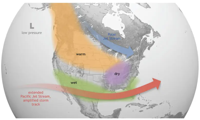
Figure 1. Jet Stream Pattern of El Niño Winter Weather Impact in North America
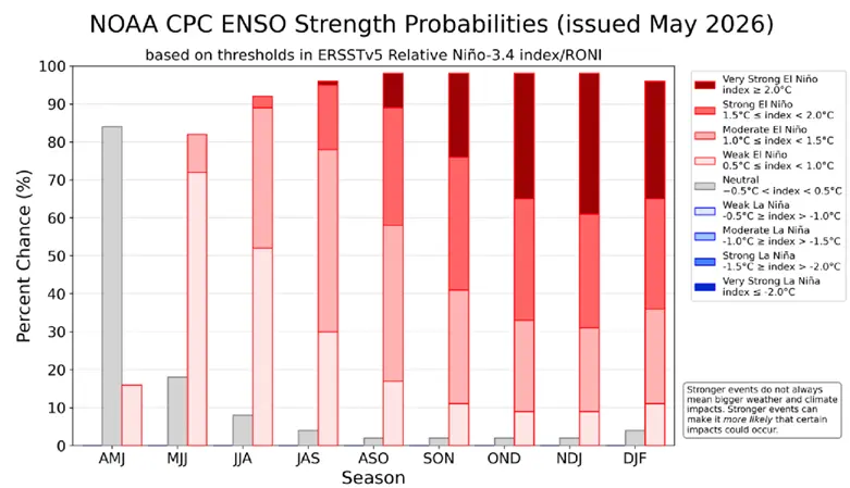
Figure 2. NOAA Current Probabilities of El Niño Strength
The challenge with both El Niño and La Niña events is the predictability of localized impacts. These weather phenomena create widespread and long-lasting impacts rather than just a single weather event. Historical data can be useful to analyze but note that they do not predict how mild or severe an upcoming event may look.
Typically, an El Niño in Iowa is followed by warmer winter temperatures, although the possibility of El Niño beginning this summer and carrying out through winter are possible. Winter conditions are often milder than average along with below average snowfall, as shown above in Figure 1. The last strong El Niño (2015-16) saw above average temperatures and heavy rainfall causing severe flooding along the Mississippi River.
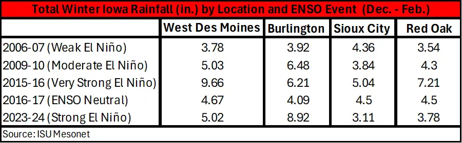
As shown in Table 1, rainfall across Iowa during recent El Niño and ENSO-neutral years (neither El Niño or La Niña conditions) has varied by intensity and location. During the most recent very strong El Niño in 2015-16, rainfall across select Iowa cities from December to February was consistently above 5 in. West Des Moines, Iowa saw over 9 in., while Sioux City received 5 in. As the data tells us, stronger events do not suggest stronger impacts but do make certain impacts more likely although the conditions can vary.
Table 1. Total Rainfall for Selection Iowa Locations During ENSO Event Dec. - Feb.
For illustrative purposes, based on data from historical El Niño events from 1895 to 1997, states like Iowa and much of the Midwest experienced wet to somewhat wet conditions for the months of October through December (Figure 3). Rainfall across the state during El Niño can increase flood risks, particularly in parts of the Midwest.
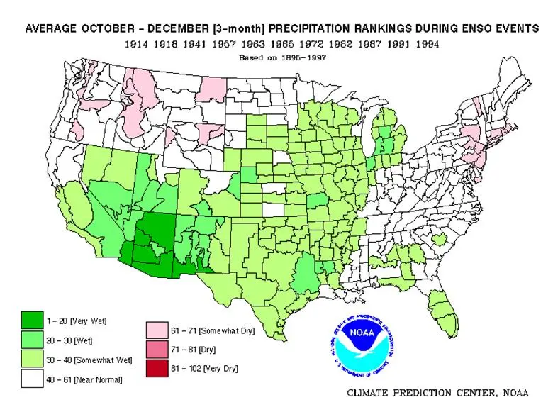
Figure 3. NOAA El Niño Precipitation based on 1895-1997
While the vast majority of Iowa’s crop is harvested before the month of November, the potential for increased precipitation in late summer into early fall extending throughout the winter could cause delays in harvest and fall field work if weather events bring heavy precipitation to the region.
Want more news on this topic? Farm Bureau members may subscribe for a free email news service, featuring the farm and rural topics that interest them most!